|
home | photosimulation & design viz | interchanges | sr99 and hammett road interchange |
|
SR99 and Hammett Road Interchange
Photosimulations
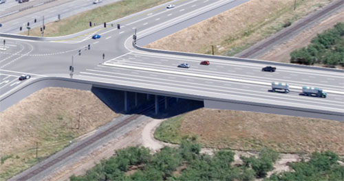
CalTrans and Stanislaus County, Salida, California POITRA Visual provided photo-realistic simulations for the SR99 and Hammett Road Interchange reconstruction project. The redesign eased congestion at peak traffic volume hours at Hammett Road caused by the interchange accesses and lack of storage. Two main alternatives for the interchange were explored: an alternative that featured upgrading the existing full diamond interchange and another that created a half diamond with the other two ramps accessing Salida Boulevard, the nearby major cross street to Kiernan Ave. Photo-simulation was the medium chosen as the best way to accurately communicate the different impacts of each proposed design to project team members and to the public. |


POITRA Visual also produced graphics for each alternative depicting land use variations. |

|
| |||||||||||||||||||||||||||||||||||||||||


|
POITRA used traditional digital painting techniques to remove or adjust properties and roadways eliminated or moved in each of the new design alternatives from the Engineer provided base photograph. POITRA artists then added the overpass structure, interchange ramps, railroad overpass structure, retaining walls, laneage, traffic control, sidewalks, bike path, medians, fill slopes and landscaping. Many future off system streets were also represented in the simulation based upon available community planning information. Great care was taken to ensure that the new lane markings were correct as they would help agencies understand the scope of the project. The previous bridge and roadway design experience of the POITRA Visual principals played a key role in quickly interpreting the Engineer's design plans and transforming the information for four different alternatives into an accurate illustrations of each proposed condition. POITRA also produced a land use graphic for each alternative, again from community planning information, to help agencies understand the land impacts of the different alternatives.
The final aerial simulation images were used as meeting materials for the CalTrans and Stanislaus County design and public involvement process. |
Take a Closer Look! The highly developed skills of the Artists at POITRA Visual make your project come alive. (click to magnify). | ||||||||||||||||||