|
* For example, POITRA created and maintained the public information websites for the Southeast Corridor MIS (TREX), the North Metro Major Investment Study (MIS) and the US36 Corridor MIS beginning in 1998. The North Metro Corridor Environmental Impact Statement (EIS) is part of the Regional Transportation District's (RTD) new FasTracks Project, which is advancing several corridors to the design phase.
|

|
home | photosimulation & design viz | commuter rail transit | north metro 124th avenue future garage |
|
North Metro 124th Avenue Future Garage
Photosimulations
RTD FasTracks, Thornton, Colorado The North Metro Corridor is one of several proposed transit corridors in the Denver Regional Transportation District's (RTD) FasTracks program that have been evaluated throughout the Metro area as Environmental Impact Statements (EIS). Most of the corridors originate in downtown Denver's Union Terminal (DUT) and radiate out to the suburbs. POITRA has provided several types of services on nearly all of these corridors at some point in their long histories.* The North Metro Corridor takes advantage of abandoned or little used frieght rail corridors that served Denver's northern suburbs. Because of the length of the line and possible interaction with commercial freight rail a heavy commuter rail concept was proposed. At this stage of the project only Electric Multiple Units (EMU) were being evaluated. The EIS called for a large commuter station and park-n-ride at 124th Avenue in Thornton. The station would occupy an open area surrounded by 4f neighborhoods and the historical Eastlake Granary located just to the north. A future parking garage was designed into the station site. |


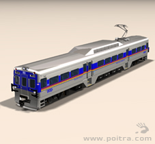

POITRA artists created custom 3D models of the EMU commuter vehicle with RTD marking combinations. POITRA often creates custom transit vehicles at no cost to the project. |

| ||||||||||||||||||||||||||||||||||||||||||||||||||||||||||||||||||
|
| |||||||||||||||||||||||||||||||||||||||||||||||||||||||||||||||||


|
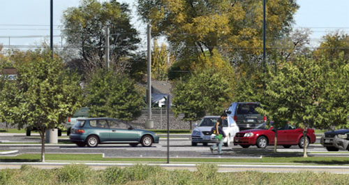
A design visualization was needed to address all these issues. It was preferred to include them together in a single overall panoramic photosimulation for public meetings and break out the individual elements as needed. POITRA photographers selected a vantage point that made all the elements visible and at a great enough distance to eliminate lens warp. POITRA artists prepared the base photograph to recieve the elements of the proposed corridor using traditional digital painting techniques. This included separating and removing foreground trees within the station footprint from background trees and buildings.
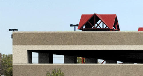
POITRA created a 3D model that included the new gravel roadbed, ties, rails and the EMU catenary system. The station was modeled to include the platforms, shelters, stairs, ramps, railings and other station amenities. POITRA also modeled the curbs and islands of bus loading and parking areas including overhead lighting. Markers for individual parking lot trees were placed in the model. The site model was then camera matched, lighted, rendered and composited with the base photograph. Tree markers were replaced with tree images in the simulation and station patrons, automobiles and buses were added. The parking to the south was reconfigured to accept a model of the future parking garage in the ultimate buildout simulation. POITRA based the garage architecture upon similar structures already existing within the RTD system. The POITRA EMU vehicle was added to the corridor for each version of the simulation. The garage portion of the simulation was broken out and used to address questions about the location and appearence of the future structure.
The finished simulations were used in meetings with Fastracks public stakeholders, on the project website, in newsletters and in the EIS document. |
Mind the details! The highly developed skills of the Artists at POITRA Visual make your concept a reality. (click to magnify) | |||||||||||||||||||||||||||||||||