|
home | photosimulation & design viz | viaduct structures | i-70 east at vine street |
|
I-70 East at Vine Street
Photosimulations
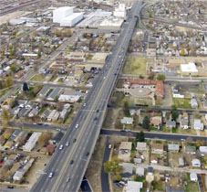
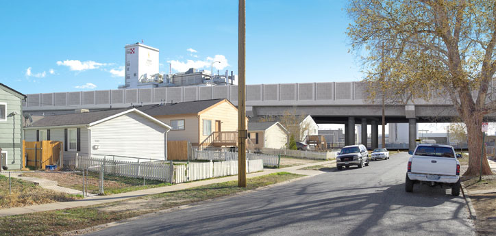
CDOT, Denver, Colorado Interstate 70 is the primary east west artery through the Denver metropolitan area. Many of its bridges and viaducts dated to the early interstate era and were in need of upgrade and replacement. A large portion of I-70 just east of I-25 was elevated on one of these aging viaducts badly in need of structural and capacity improvements. Half of this viaduct had been rebuilt by an earlier project. Major questions remained as to exactly how to replace the second half. The precise alignment was one these questions. The Colorado Department of Transportation (CDOT) conducted the I-70 East Environmental Impact Study (EIS) to determine the answers. POITRA Visual was selected to provide design visualization services and a comprehensive public information website for the project.* Photo-simulation was thought to be the best medium for accurate and convincing presentations. |
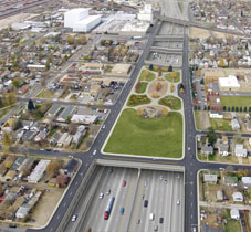
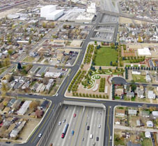
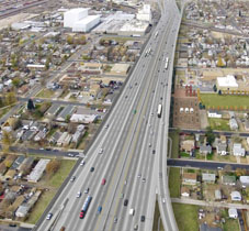
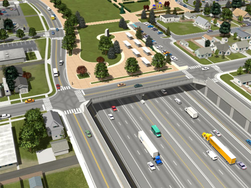
POITRA created aerial view visual simulations of the proposed I-70 East Project SDEIS alternatives. |
| ||||||||||||||||||||||||||||||||||||||||||||||||||||||||||||||||||
|
| |||||||||||||||||||||||||||||||||||||||||||||||||||||||||||||||||


|
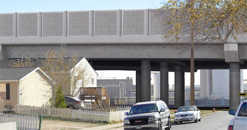
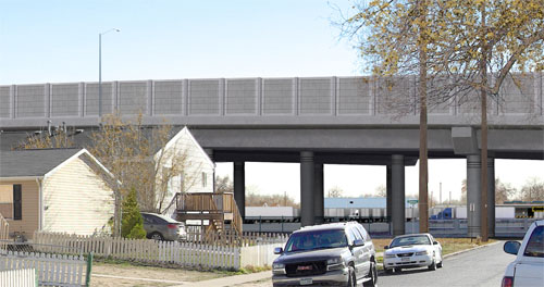
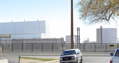
All of the Supplemental Draft EIS (SDEIS) alternatives followed the existing alignments with variations that shifted that alignment to the north or to the south, each preserving different existing business and 4f properties. A visual simulation was made at Vine Street to illustrate the different alternatives on the Purina Plant, an important local employer. POITRA photographers made a corridor photo survey from which all the base photographs were selected by the Engineer. POITRA modelers created an accurate 3D model of the northern shift viaduct, the southern shift viaduct and the partial cover alternative which placed I-70 below grade. POITRA principal's design experience ensured accurate models. These models were then camera matched with the base photograph. Artists could then determine what areas of the background would need to be restored, removed or separated from the background.
The existing viaduct and several residences and the Purina Plant were to be removed from the path of one or more of the alternative alignments. Each alternative affected a different set of residences and other structures. In the simulation view these removals would exposed buildings and truck trailer parking beyond. POITRA artists carefully reproduced these newly exposed scenes as they removed the appropriate foreground buildings and the old viaduct for each alternative. This work was accomplished using traditional digital painting techniques. The 3D model was then lighted to match the photograph, rendered and combined with it to create the final simulation. Special effort was required to bring the bare foreground trees to the front of the viaduct and to correctly depict the newly exposed industrial scenes behind.
POITRA displayed the simulations on the I-70 East EIS public website at the request of the Engineer. The finished simulations were also used by CDOT in the I-70 East EIS public meetings, newsletters and as exhibits in the SDEIS Document. |
Take Another Look! POITRA created an animated 3d model of the I-70 East SDEIS Preliminarily Identified Preferred Alternative. (click to magnify)
Take Another Look! POITRA created an animated 3d model of the I-70 East SDEIS Preliminarily Identified Preferred Alternative. (click to magnify) | ||||||||||||||||||||||||