|
Existing daily traffic volumes on I-25 are in the range of 16,000 vpd. All existing freeway segments are estimated to operate at LOS A during the peak hour. All merge/diverge movements along I-25 between Van Buren Street and
Goddard Avenue operate at LOS A during the peak hour, even though acceleration lengths for merging traffic are substantially deficient. All existing signalized and unsignalized
intersections operate at LOS C our better during the AM and PM peak hours.
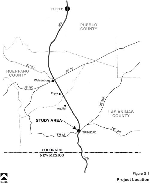
An accident history evaluation was conducted for the I-25 corridor through Trinidad to identify specific locations with high occurrences of accidents. The accident rate and
severity on this segment of I-25 is slightly higher than average when compared to other segments of urban interstate highway statewide. There are two main areas of accident
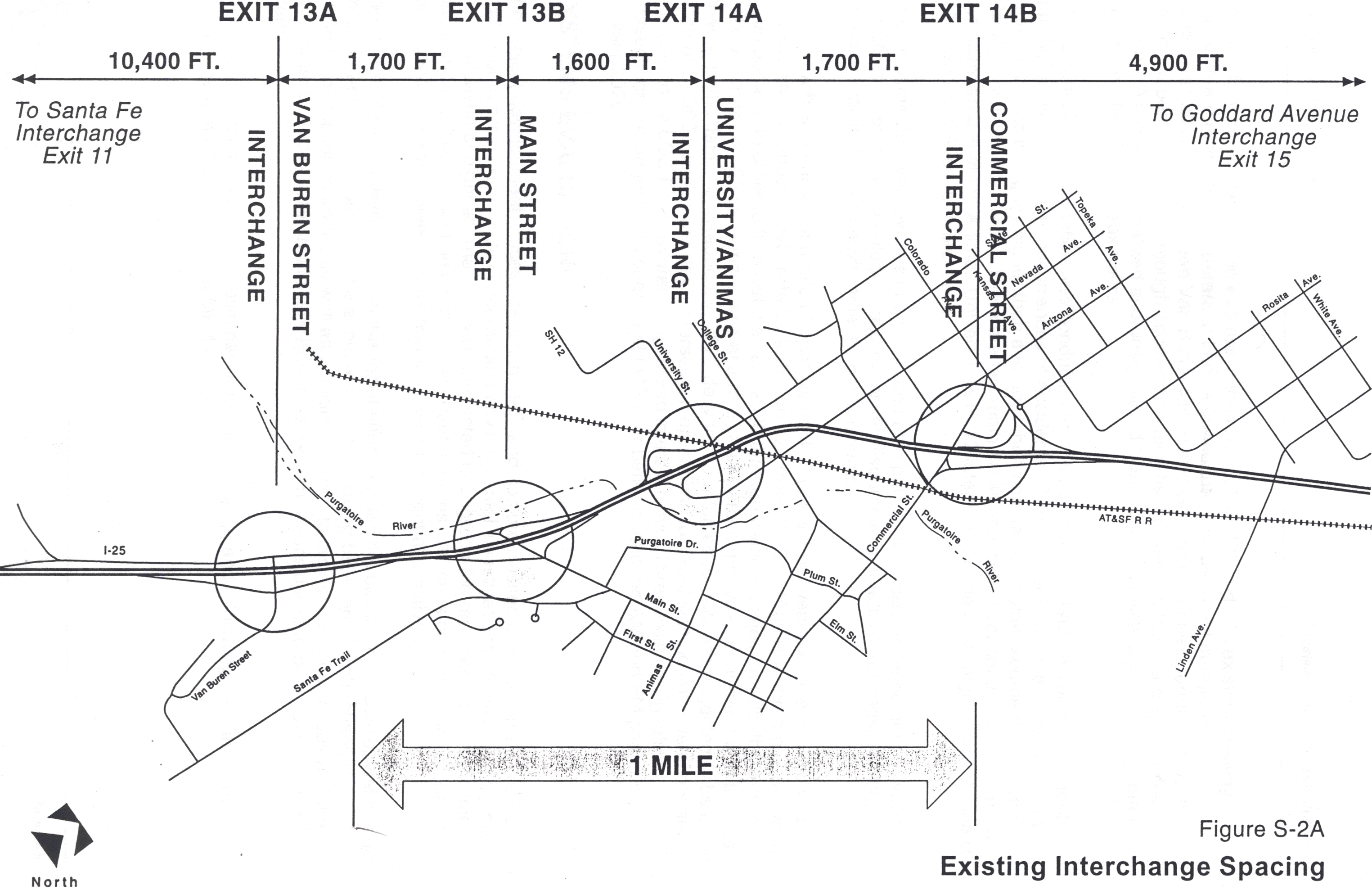
concentration. The most significant area is at the Animas/University/S.H. 12 interchange, the other high accident area is at the Goddard Avenue Interchange.
An environmental overview has been prepared as a part of the project development process. The EO focuses on archaeological and historical resources, vegetation, wetlands, wildlife,
environmental justice and environmental contaminants.
Local growth is projected at a rate of approximately 2 percent per year over the next 20 years. Actual average annual growth rate for traffic on I-25 from 1993 to 1999 is in the range of five to seven percent. In order to forecast the year 2020 through traffic volumes on I-25, the existing traffic volumes on I-25 were increased at a rate of six percent per year, consistent with the past six-year
traffic data. Consequently, 2020 daily traffic volumes for I-25 are projected to be in the range of 51,000 vehicles per day. Intersection operations for 2020 with no improvements are projected to be LOS F for several unsignalized intersections. Three existing signalized intersections are projected to operate at LOS C or better during the AM and PM peak hours in the year 2020.
SYSTEMS EVALUATION
The project development process began in 1993 and has progressed over this time to reflect funding programs, community concerns and environmental investigations. Initially, a systems-level evaluation of eight alternatives was conducted to upgrade the replacement of deficient ramps and improve connections to the local street systems. A series of evaluation criteria and corresponding weights were established to assess the eight alternatives.
A Preferred System alternative from this initial effort, formed the basis for the conceptual design which is determined to achieve the approved safety, spacing between the interchanges, moderate disruption to traffic, as well as a minimal impact to residences, businesses and the environment. Additionally, this initially Preferred System is considered to be a cost effective alternative.
This system evaluation results in eliminating one interchange and relocating the Van Buren interchange to a future location at MP
12.
PROJECT LEVEL FEASIBILITY STUDY
Conceptual Design
Alternative 6 was used as the basis for developing the
conceptual design. Several options for
Alternative 6 were presented at a public workshop on December 7, 1999.
The public favored inclusion of Options A
and C, which included shifting the alignment for the viaduct portion to the
east to provide a 65 MPH design speed for this portion of the viaduct and
eliminate significant impacts to existing businesses on the west side of I-25
at Commercial Street.
Since then, the project team (FHU, CDOT, the City of
Trinidad and FHWA) have analyzed the potential weave configuration between the
Van Buren Street Interchange and the Main Street Interchange in further
detail. The team also developed a
design alternative for the new connection of S.H. 12 with Main Street to avoid
the historic Trinidad Tire Store. The
new section of SH 12 between Main Street and the existing SH 12 is recommended
to have an access category of NRB (Non-Rural Arterial), which is consistent
with the access category on the existing section of SH 12 west of I-25.
The section Main Street which will be
designated as SH 12 (between I-25 and Santa Fe Trail) is recommended to have an
access category of NRC in order to maintain existing accesses along Main
Street.
FHWA expressed concerns the proposed
improvements may not adequately address the substandard weave length.
Further, it was determined that the existing
bridge overpass at Van Buren would have to be replaced due to inadequate
vertical clearance and span lengths.
With these issues in mind, the project team identified a modified plan;
relocate the existing interchange at Van Buren Street south to approximately
M.P. 12. This modification would
provide the recommended one-mile spacing between the interchanges at Santa Fe
Trail, M.P. 12 and Main Street. These
considerations were made part of the Preferred Alternative. This modification
has received public support, as documented in a series of letters which are
included in Appendix A.
As such, we identified two stages for
implementation of the Preferred Alternative:
|
Interim Condition:
|
|
All improvements north of the existing interchange at Van Buren, with a temporary connection tothe existing facility immediately north. This would require removal of the existing north ramps at Van Buren.
|
|
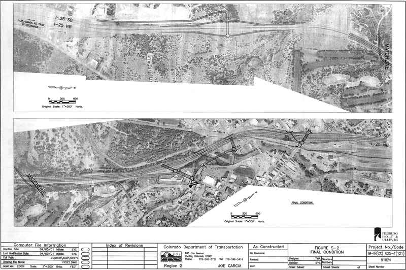
Final Condition:
|
|
Construction of an interchange at Mile Post 12 and removal of the existing interchange at Van Buren. This would require a new grade separation
under I-25 for the Sopris Road connection to Van Buren. The interchange at M.P. 12 would require extension of the west frontage road to provide access to the interchange.
|
Traffic Analysis
Year 2020 traffic volumes were modeled for both
the Interim Condition and the Final Condition, and the Preferred System levels
of service were compared with the “No-Build” levels of service.
The majority of the I-25 freeway segments
between Van Buren and Goddard Avenue are projected to operate at LOS C during
the PM peak hour. The level of service
in both directions of the freeway are expected to be LOS B or better outside
this segment of I-25. All projected
year 2020 merge-diverge freeway movements for the Preferred System are expected
to operate at LOS C or better.
The projected year 2020 AM and PM peak hour
turning movement traffic volumes were used to determine projected year 2020
intersection operations as key locations for the Interim Condition and the
Final Condition. With traffic control
improvements identified in this Study, all signalized intersections are
projected to operate at LOS C or better during the AM and PM peak hours in the
year 2020.
Replacing the Van Buren Interchange with the new
interchange at M.P. 12 results in minor shifts in the traffic patterns, with
slightly more traffic oriented to the Main Street Interchange.
The Main Street ramp terminal intersections
and the intersection of Mains Street/Santa Fe Trail are projected to operate at
acceptable levels of service. Emergency
vehicle response times will not be significantly affected by relocating the
existing interchange from Van Buren to M.P. 12.
Phasing Plan/Funding Plan
Ten phases were conceptually identified to
maintain traffic control during construction.
Phases 1 through 5 complete the project to the Interim Condition, Phases
6 through 10 complete the project to the Final Condition.
Some phases of construction will require
temporary crossovers and two-way traffic operation on one of the two existing
northbound and southbound highway sections.
Opinions of Probable Construction Cost are summarized as follows:
|
Interim Condition:
|
|
$50,958,000
|
|
Final Condition:
|
|
$19,204,000
|
|
Total Project:
|
|
$70,162,000
|
CDOT has identified $44.1 million in funding for the Interim Condition over the next five years.
|