|
home | photosimulation & design viz | antennas & towers | o'hare west chicago at dayton street |
|
O'Hare West Chicago at Dayton Street
Photosimulations
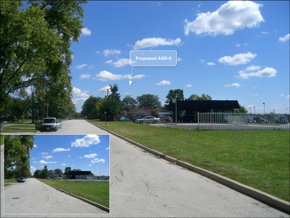
FAA, West Chicago, Illinois The Federal Aviation Administration (FAA) was surveying sites for the installation of a new ASR9 Antenna to serve the air traffic control system at O'Hare International Airport in Chicago. The FAA and local authorities, including O'Hare Airport, required a complete feasibility study. This study included environmental considerations such as view impacts. It would consider a number of tower locations and address visual impact concerns from specific areas. POITRA was selected to provide the graphics support for the project. POITRA created a series of photosimulations for the two early canidate tower sites in West Chicago and in Warrenville. |
Take a closer look! The ASR9 radar antenna and tower was created by POITRA modelers (click to magnify). | ||||||

|
| |||||||||||||||||||||||||||||||||||


|
The Engineer supplied excellent photographs representing the four most important view sheds. Each would be used as base photographs for photosimulations of each site.
POITRA modelers created a detailed 3D model of the ASR9 Radar Antenna and the proposed 76ft tall tower. An equipment building, site fencing and gates from POITRA model libraries were also used to create a site model for each site. The west Chicago site model was camera matched to the Dayton Street base photograph, lighted and rendered. The renders were then composited to the base photograph and traditional digital painting methods used to finish the simulations. The project originally called for the antennas to be painted international orange but because of visual impact concerns and the sites being quite distant from the actual airport, the paint color in the simulations was modified to gull grey. POITRA had prior experience specifically with airport radar towers and antennas and easily understood the plans for the various components. Graphic artists at POITRA marked the tower locations to make the simulations into figures for the study document. POITRA also created graphic map figures that identified the tower site options and the view shed locations for both sites.
All of the POITRA figures appeared in the final study document and visually complimented the high quality of the rest of the document. |
Take a Closer Look! POITRA graphic artists can help any project by creating stunning professional settings for your project information. (click to magnify) | ||||||
